The climate of cities substantially differs from the climate of their natural surroundings, which can be explained by the surface characteristics of urban areas. The narrow streets, the impervious surfaces, the lack of vegetation and the large heat capacity of buildings lead to a warmer, drier and more turbulent urban atmosphere than what develops in the neighbouring rural areas. These effects may enhance certain consequences of climate change, increasing the exposure and vulnerability of cities depending on their size, location and economic situation.
Regional climate models (RCMs) provide scientifically sound, quantitative estimations about the future climate change of a country or a region. Due to their typical resolution (in general 10–50 km) and the simplified methods implemented for describing the atmosphere – urban surface interactions, these models alone cannot be applied for urban climate investigations. In contrast, land surface models are suitable tools for these objectives, because instead of the entire atmosphere, they simulate solely the interactions between the surface and a shallow (couple of 10 m) air layer above it. Therefore, running these models requires small computational capacity that allows to apply them on finer resolution and to characterise urban land cover and relevant physical processes more precisely.
At the Hungarian Meteorological Service (OMSZ) we perform urban climate investigations with the SURFEX (Masson et al., 2013) land surface model, whose first version was developed at Météo France. SURFEX can be applied not only for cities, but for three additional surface types (natural surfaces, lakes and seas) and for their compositions as well. The state of the atmosphere influences the surface processes, and this impact is prescribed as upper boundary conditions of the model. These forcings can be derived from available measurements or model results. Over cities the TEB (Masson, 2000) scheme is applied, which approximates urban structures as street canyons. TEB takes into account heat conduction through roofs and walls, and also anthropogenic (industrial and by transportation) heat and moisture emission.
At OMSZ SURFEX is applied for two cities, Budapest and Szeged with 1 km resolution. Atmospheric forcings are provided by our RCMs.The simulation procedure has 3 main steps:
- In the first step the model is thoroughly tested. A sensitivity analysis is performed on a few-year period in order to understand the model’s behaviour and to define its optimal configuration. According to results of these investigations, it can be concluded that SURFEX – contrary to the driving regional climate model – is able to reveal the well known feature of urban climate, i.e., urban heat island, its spatial characteristics (Figure 1) and diurnal evolution as well (Zsebeházi et al., 2015).
- In the next step – similarly to climate modelling – we investigate how the model is capable of describing the climate characteristics of cities on a longer (multi-decadal) timescale. The performance of SURFEX is analysed against observations, provided by urban stations (e.g., http://adatok.geo.u-szeged.hu/allomasok-elhelyezkedese.php) or satellite data.
- Finally to study the climate change impacts on cities, simulations for the future are performed. In this case the atmospheric forcings are derived from regional climate projections based on different anthropogenic scenarios.
The SURFEX results provide information about the meteorological characteristics of urban climate and can serve input for further impact studies in urban planning (e.g., health care, architecture).
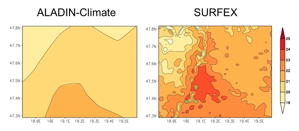
Figure 1
Summer mean 2-m temperature (°C) for 1991–2000 over
Budapest according to the 10 km resolution ALADIN-Climate RCM and 1 km resolution SURFEX results
References
Masson, V., 2000: A Physically-based Scheme for the Urban Energy Budget in Atmospheric Models. Bound.-Layer Meteor. 94, 357–397. [PDF]
Masson, V., Le Moigne, P., Martin, E., Faroux, S., Alias, A., Alkama, R., Belamari, S., Barbu, A., Boone, A., Bouyssel, F., Brousseau, P., Brun, E., Calvet, J.-C., Carrer, D., Decharme, B., Delire, C., Donier, S., Essaouini, K., Gibelin, A.-L., Giordani, H., Habets, F., Jidane, M., Kerdraon, G., Kourzeneva, E., Lafaysse, M., Lafont, S., Lebeaupin Brossier, C., Lemonsu, A., Mahfouf, J.-F., Marguinaud, P., Mokhtari, M., Morin, S., Pigeon, G., Salgado, R., Seity, Y., Taillefer, F., Tanguy, G., Tulet, P., Vincendon, B., Vionnet, V., Voldoire, A., 2013:The SURFEXv7.2 land and ocean surface platform for coupled or offline simulation of earth surface variables and fluxes. Geoscientific Model Development 6, 929–960. [PDF]
Zsebeházi, G., Krüzselyi, I., Szépszó, G., 2015: Study of urban climatology over Budapest with SURFEX/TEB model at the Hungarian Meteorological Service. ALADIN-HIRLAM Newsletter 5, 107–113. [PDF]